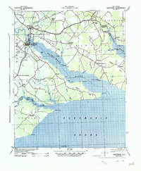
1940 Map of Hertford
USGS Topo · Published 1940About this map
The Hertford waterfront and the surrounding coastal necks define this landscape along the Perquimans River and Albemarle Sound. This 1940 Army Corps of Engineers survey illustrates a region deeply connected to the water, where historic points like Harvey Point and Drummond Point reach into the sound. The transportation network is anchored by the Norfolk Southern and Southern Railroad, which served the local industry, including a Saw Mill near Winfall. Inland, the map reveals a collection of small rural communities and civic sites, from Newhope Proper to a Prison Camp near Woodville. Local commerce and communication are evidenced by the Durants Neck P O and several riverside landings such as Newby Landing and Redbank Landing, which provided essential access for the agricultural areas of Durants Neck and Harveys Neck.
Find a feature on this map
59 named features on this map. Tap any name to fly to it.
Don’t see what you’re looking for? This feature index may not catch every label — zoom into the map to look around manually.
Map Details
Editions of this 1940 Hertford Map
2 editions found
Other maps of this area

1904 · Edenton
USGS Topo · 1:62,500

1906 · Hertford
USGS Topo · 1:62,500

1906 · Beckford
USGS Topo · 1:48,000

1907 · Beckford
USGS Topo · 1:62,500

1940 · Hertford
USGS Topo · 1:62,500

1940 · Beckford
USGS Topo · 1:62,500

1940 · Wade Point
USGS Topo · 1:62,500

1940 · South Mills
USGS Topo · 1:62,500

1942 · Edenton
USGS Topo · 1:62,500

1943 · Wade Point
USGS Topo · 1:62,500