
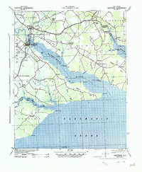
1940 Map of Hertford
USGS Topo · Published 1940About this map
Hertford and its surrounding coastal necks dominate this landscape at the confluence of the Perquimans River and the Albemarle Sound. Published by the War Department, this survey documents a rural water-bound economy shortly before World War II, where life was organized around the intricate shoreline of Harveys Neck and Durants Neck. Navigation was central to the region's identity, evidenced by prominent sites like White Hat Landing and Newby Landing.
Find a feature on this map
62 named features on this map. Tap any name to fly to it.
Don’t see what you’re looking for? This feature index may not catch every label — zoom into the map to look around manually.
Map Details
Editions of this 1940 Hertford Map
2 editions found
Other maps of this area

1904 · Edenton
USGS Topo · 1:62,500

1906 · Hertford
USGS Topo · 1:62,500

1906 · Beckford
USGS Topo · 1:48,000

1907 · Beckford
USGS Topo · 1:62,500

1940 · Beckford
USGS Topo · 1:62,500

1940 · Wade Point
USGS Topo · 1:62,500

1940 · South Mills
USGS Topo · 1:62,500

1942 · Edenton
USGS Topo · 1:62,500

1943 · Wade Point
USGS Topo · 1:62,500

1943 · Columbia
USGS Topo · 1:125,000