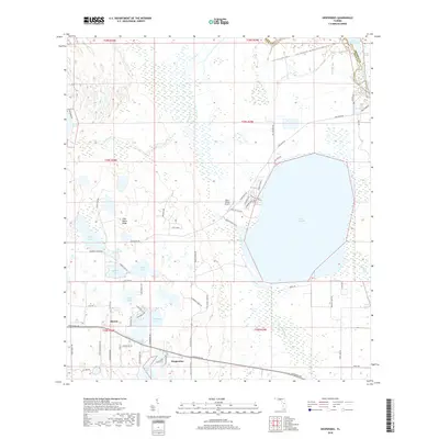
2018 Map of Hesperides
USGS Topo · Published 2018About this map
Lake Rosalie dominates the eastern landscape of this Polk County region, where the high ground of the Lake Wales Ridge meets the vast wetland systems of the Kissimmee River basin. The area is defined by its numerous named water bodies, including Saddlebag Lake, Lake Hatchineha, and Tiger Lake, creating a complex aquatic network characteristic of central Florida's lake country. Small communities like Hesperides and Alcoma are connected by a grid of rural roads, including Hesperides Rd and Camp Mack Rd, which navigate between the citrus groves and marshy depressions.
Find a feature on this map
77 named features on this map. Tap any name to fly to it.
Don’t see what you’re looking for? This feature index may not catch every label — zoom into the map to look around manually.
Map Details
Editions of this 2018 Hesperides Map
This is the sole edition of this map. No revisions or reprints were ever made.
Other maps of this area

1952 · Lake Wales
USGS Topo · 1:24,000

1952 · Lake Weohyakapka SE
USGS Topo · 1:24,000

1952 · Lake Weohyakapka NE
USGS Topo · 1:24,000

1952 · Babson Park
USGS Topo · 1:24,000

1952 · Hesperides
USGS Topo · 1:24,000

1952 · Lake Weohyakapka
USGS Topo · 1:24,000

1953 · Cypress Lake
USGS Topo · 1:24,000

1953 · Dundee
USGS Topo · 1:24,000

1953 · Lake Hatchineha
USGS Topo · 1:24,000

1955 · Orlando
USGS Topo · 1:250,000