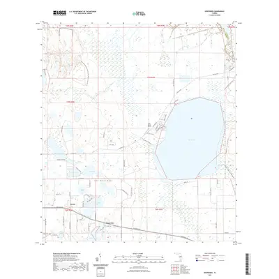
2021 Map of Hesperides
USGS Topo · Published 2021About this map
Lake Wales Ridge defines the topography of this central Florida landscape, where a dense network of lakes and marshes transitions into established citrus groves and small settlements. In the southern portion of the quadrangle, the community of Hesperides sits along Hesperides Rd, south of Saddlebag Lake and Lake Aurora. The area is characterized by its complex hydrology, featuring large water bodies like Lake Rosalie and the meandering Catfish Creek, which flows through the Allen David Broussard Catfish Creek Preserve State Park. To the west, Alcoma is situated near Thomas Lake and the Saint Anne Lake shrine. This 2021 survey also details local infrastructure such as Bent Willies Airport and the winding course of Tiger Creek, reflecting the region's historical reliance on its water resources and the sandy uplands of the ridge for agriculture.
Find a feature on this map
78 named features on this map. Tap any name to fly to it.
Don’t see what you’re looking for? This feature index may not catch every label — zoom into the map to look around manually.
Map Details
Editions of this 2021 Hesperides Map
This is the sole edition of this map. No revisions or reprints were ever made.
Other maps of this area

1952 · Lake Wales
USGS Topo · 1:24,000

1952 · Lake Weohyakapka SE
USGS Topo · 1:24,000

1952 · Lake Weohyakapka NE
USGS Topo · 1:24,000

1952 · Babson Park
USGS Topo · 1:24,000

1952 · Hesperides
USGS Topo · 1:24,000

1952 · Lake Weohyakapka
USGS Topo · 1:24,000

1953 · Cypress Lake
USGS Topo · 1:24,000

1953 · Dundee
USGS Topo · 1:24,000

1953 · Lake Hatchineha
USGS Topo · 1:24,000

1955 · Orlando
USGS Topo · 1:250,000