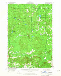
1954 Map of Hetherton
USGS Topo · Published 1966About this map
Pigeon River State Forest and several neighboring preserves dominate this northern Michigan landscape during the mid-1950s. The region is defined by a dense network of glacial lakes and river systems, including the Black River and Cornwall Creek. Human activity is concentrated in forest management and seasonal recreation, evidenced by the State Forest Headquarters and the Pigeon River Lookout Tower. Unique local landmarks like the Paul Bunyan Punch Bowl and the Lansing Club reflect the area's identity as a timber and sporting destination. Small settlements like Hetherton and Johannes anchor the southern portion of the map, while the Gingell Cem provides a point of interest for genealogists. The map also documents river crossings and infrastructure such as the Shingle Mill Bridge and Saunders Dam, which speak to the historic management of these waterways for logging and conservation.
Find a feature on this map
61 named features on this map. Tap any name to fly to it.
Don’t see what you’re looking for? This feature index may not catch every label — zoom into the map to look around manually.
Map Details
Editions of this 1954 Hetherton Map
4 editions found
Other maps of this area

1949 · Lewiston
USGS Topo · 1:62,500

1949 · Otsego Lake
USGS Topo · 1:62,500

1950 · Lewiston
USGS Topo · 1:24,000

1950 · Johannesburg
USGS Topo · 1:24,000

1950 · Turtle Lake
USGS Topo · 1:24,000

1951 · Turtle Lake
USGS Topo · 1:24,000

1951 · Johannesburg
USGS Topo · 1:24,000

1951 · Lewiston
USGS Topo · 1:24,000

1954 · Gaylord
USGS Topo · 1:62,500

1954 · Hetherton
USGS Topo · 1:62,500