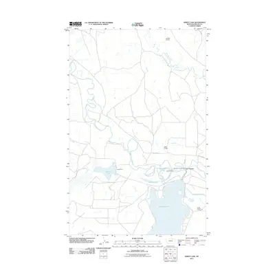
2011 Map of Hewitt Lake
USGS Topo · Published 2011About this map
Milk River meanders through the heart of this Phillips County landscape, defining a network of water management and recreation in the early 21st century. The complex interplay of natural and engineered waterways is anchored by the Nelson Reservoir and the Hewitt Lake national wildlife refuge area. Evidence of long-standing transit points remains at Cree Crossing, where Cree Xing and the Milk River Ford Bridge provide access across the winding river. Water distribution for local agriculture is visible through features like the Nelson South Canal and McNeil Slough. The landscape is further characterized by dramatic prairie drainage features, such as Alkali Coulee and Joe Bell Coulee, while public recreation is centered at the Nelson Reservoir Campground near the water's edge.
Find a feature on this map
17 named features on this map. Tap any name to fly to it.
Don’t see what you’re looking for? This feature index may not catch every label — zoom into the map to look around manually.
Map Details
Editions of this 2011 Hewitt Lake Map
This is the sole edition of this map. No revisions or reprints were ever made.
Other maps of this area

1905 · Bowdoin
USGS Topo · 1:62,500

1905 · Saco Special
USGS Topo · 1:62,500

1920 · Cowan
USGS Topo · 1:125,000

1954 · Glasgow
USGS Topo · 1:250,000

1957 · Glasgow
USGS Topo · 1:250,000

1958 · Glasgow
USGS Topo · 1:250,000

1968 · Tattnall
USGS Topo · 1:24,000
1968 · Hewitt Lake
USGS Topo · 1:24,000

1968 · Austin Lake
USGS Topo · 1:24,000

1968 · Hewitt Lake SW
USGS Topo · 1:24,000