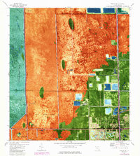
1973 Map of Hialeah SW
USGS Topo · Published 1984About this map
The settlement of Sweetwater sits at the edge of a rapidly shifting landscape where suburban growth meets the expansive wetlands of the Everglades. This 1970s orthophotomap documents a period of significant drainage and development, with the Floridas Turnpike Extension and the Seaboard Coast Line railroad carving paths through the terrain. To the west, the Dade-Broward boundary separates more developed lands from the Everglades Wildlife Management Area, where a Lookout Tower and Airboat Trail signify the wilder character of the conservation zone.
Find a feature on this map
35 named features on this map. Tap any name to fly to it.
Don’t see what you’re looking for? This feature index may not catch every label — zoom into the map to look around manually.
Map Details
Editions of this 1973 Hialeah SW Map
2 editions found
Other maps of this area

1949 · Opalocka
USGS Topo · 1:24,000

1949 · South Miami NW
USGS Topo · 1:24,000

1950 · Hialeah
USGS Topo · 1:24,000

1950 · South Miami
USGS Topo · 1:24,000

1955 · South Miami NW
USGS Topo · 1:24,000

1956 · South Miami
USGS Topo · 1:24,000

1956 · Miami
USGS Topo · 1:250,000

1958 · Miami
USGS Topo · 1:250,000
1962 · Hialeah
USGS Topo · 1:24,000

1962 · Opa-locka
USGS Topo · 1:24,000
Featured Places
- Tamiami, FL
- University Lakes Mobile Home Park, FL
- Lil Abner Mobile Home Park, FL
- Miami-Dade County, FL
- United States