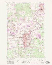
1957 Map of Hibbing
USGS Topo · Published 1983About this map
The Mahoning-Hull-Rust Mine dominates the center of this Iron Range survey, illustrating the massive scale of open-pit operations that reshaped the Mesabi topography. This industrial landscape is bisected by the Laurentian Divide, which separates the Hudson Bay and Lake Superior watersheds. The city of Hibbing and nearby Chisholm are shown in high detail, featuring numerous educational and civic institutions like the Hibbing State Jr College, Cobb-Cook Sch, and the Courthouse.
Find a feature on this map
43 named features on this map. Tap any name to fly to it.
Don’t see what you’re looking for? This feature index may not catch every label — zoom into the map to look around manually.
Map Details
Editions of this 1957 Hibbing Map
5 editions found

Other maps of this area

1951 · Hibbing
USGS Topo · 1:24,000

1951 · Buhl
USGS Topo · 1:24,000

1952 · Keewatin
USGS Topo · 1:24,000

1952 · Riley
USGS Topo · 1:24,000

1952 · Silica
USGS Topo · 1:24,000

1952 · Little Swan
USGS Topo · 1:24,000

1954 · Hibbing
USGS Topo · 1:250,000

1955 · Dewey Lake SE
USGS Topo · 1:24,000

1955 · Dewey Lake
USGS Topo · 1:24,000

1957 · Hibbing
USGS Topo · 1:250,000