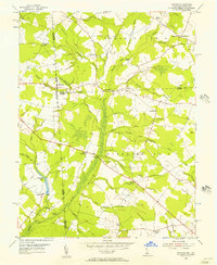
1955 Map of Hickman
USGS Topo · Published 1957About this map
The Delaware Maryland border defines the western edge of this 1950s agricultural landscape, where intricate drainage networks like Marshy Hope Creek and Short and Hall Ditch demonstrate a history of managed wetlands. Local life in Sussex and Caroline and Kent counties centers on small crossroads settlements and community landmarks, such as Bethel Ch and Epworth Ch. A prominent Lookout Tower stands near Adams Crossroads, overlooking a patchwork of timber and field. In the south, Smithville Lake and the Bloomery Bridge mark a shift toward the more aqueous terrain of the Nanticoke watershed. The mapping of named ditches like Stafford Ditch and Polk Branch reveals the extensive human effort required to transform these coastal plain lowlands into productive farmland.
Find a feature on this map
44 named features on this map. Tap any name to fly to it.
Don’t see what you’re looking for? This feature index may not catch every label — zoom into the map to look around manually.
Map Details
Editions of this 1955 Hickman Map
2 editions found
Other maps of this area

1905 · Denton
USGS Topo · 1:62,500

1905 · Hurlock
USGS Topo · 1:62,500

1915 · Seaford
USGS Topo · 1:62,500

1918 · Harrington
USGS Topo · 1:62,500

1944 · Denton
USGS Topo · 1:31,680

1944 · Federalsburg
USGS Topo · 1:31,680

1944 · Seaford
USGS Topo · 1:62,500

1944 · Hobbs
USGS Topo · 1:31,680
1944 · Harrington
USGS Topo · 1:62,500

1946 · Salisbury
USGS Topo · 1:250,000