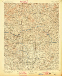
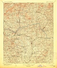
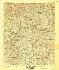
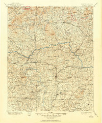
1895 Map of Hickory
USGS Topo · Published 1901About this map
The Catawba River flows through the heart of the Foothills in this late 19th-century survey, defining a landscape of early industrial activity and agrarian commerce. The river is a corridor of transport and utility, punctuated by multiple crossings such as Oxford Ford, Bowman Ferry, and Arnt Ferry. The expansion of the Southern R.R. and the Charlotte and Taylorsville R.R. mirrors the growth of settlements like Taylorsville and Hickory, while the Chester and Lenoir R.R. provides vital north-south connections through Newton and Maiden.
Find a feature on this map
120 named features on this map. Tap any name to fly to it.
Don’t see what you’re looking for? This feature index may not catch every label — zoom into the map to look around manually.
Map Details
Editions of this 1895 Hickory Map
5 editions found
Other maps of this area

1889 · Wilkesboro
USGS Topo · 1:125,000

1891 · Wilkesboro
USGS Topo · 1:125,000

1891 · Yadkinville
USGS Topo · 1:125,000

1893 · Cranberry
USGS Topo · 1:125,000

1893 · Statesville
USGS Topo · 1:125,000

1893 · Yadkinville
USGS Topo · 1:125,000

1895 · Hickory
USGS Topo · 1:125,000

1895 · Cranberry
USGS Topo · 1:125,000

1899 · Cranberry
USGS Topo · 1:125,000

1902 · Cranberry
USGS Topo · 1:125,000