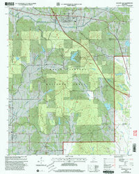
2000 Map of Hickory Flat
USGS Topo · Published 2003About this map
Hickory Flat and its surrounding crossroads communities sit at a transition point where the Holly Springs National Forest covers much of the northern landscape. This era of the late twentieth century shows a landscape defined by small rural hubs like Oaklimeter, Cornersville, and Old Myrtle, often centered around country churches and family burial grounds such as Amariah Ch, Ebenezer Ch, and the McKay Cem. The southern reach of the map transitions into the Darden Hills, where the settlement of Darden is flanked by several sandpits, indicating the local extractive economy of the time.
Find a feature on this map
50 named features on this map. Tap any name to fly to it.
Don’t see what you’re looking for? This feature index may not catch every label — zoom into the map to look around manually.
Map Details
Editions of this 2000 Hickory Flat Map
This is the sole edition of this map. No revisions or reprints were ever made.
Other maps of this area

1942 · Denmark
USGS Topo · 1:62,500

1943 · Denmark
USGS Topo · 1:62,500

1944 · Potts Camp
USGS Topo · 1:62,500

1945 · Potts Camp
USGS Topo · 1:62,500

1949 · New Albany
USGS Topo · 1:62,500

1951 · New Albany
USGS Topo · 1:62,500

1955 · Blue Mountain
USGS Topo · 1:62,500

1956 · Tupelo
USGS Topo · 1:250,000

1958 · Tupelo
USGS Topo · 1:250,000

1980 · New Albany West
USGS Topo · 1:24,000