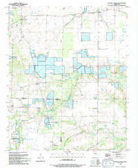
1994 Map of Hickory Plains
USGS Topo · Published 1994About this map
Hickory Plains serves as the focal point for this landscape near the boundary of Prairie and Lonoke counties. The map illustrates a rural economy increasingly dominated by specialized aquaculture, with numerous large Fish Farm complexes established along Powell Creek and Wattensaw Bayou. This industrial transition is layered over an older network of small community landmarks and family-named features, such as Burlesons Pond and the McBee Cem.
Find a feature on this map
31 named features on this map. Tap any name to fly to it.
Don’t see what you’re looking for? This feature index may not catch every label — zoom into the map to look around manually.
Map Details
Editions of this 1994 Hickory Plains Map
This is the sole edition of this map. No revisions or reprints were ever made.
Other maps of this area

1932 · Kensett
USGS Topo · 1:62,500

1935 · Kensett
USGS Topo · 1:62,500

1935 · Hazen
USGS Topo · 1:62,500

1940 · Lonoke
USGS Topo · 1:62,500

1941 · Hazen
USGS Topo · 1:62,500

1948 · Helena
USGS Topo · 1:250,000

1949 · Lonoke
USGS Topo · 1:62,500

1950 · Helena
USGS Topo · 1:250,000

1950 · Lonoke
USGS Topo · 1:62,500

1953 · Memphis
USGS Topo · 1:250,000