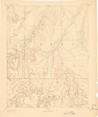
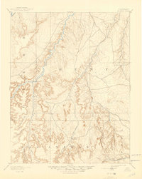
1893 Map of Higbee
USGS Topo · Published 1898About this map
The Purgatoire River carves a winding path through the southeastern Colorado high plains, anchoring a landscape defined by deep drainage systems and early cattle ranching. Surveyed in 1889, this region shows the sparse but critical settlement patterns of the late nineteenth century, most notably at Higbee and the nearby L. J. Ranch. The topography is dominated by an extensive network of canyons, including the prominent Smith Canyon, Higbee Canyon, and Horse Canyon, which provided shelter and water access in an otherwise arid environment. Along the northern edge, the A. T. & S. F. R. R. follows the river corridor, signaling the arrival of industrial connectivity to these remote grasslands. Local hydrology is further detailed through features like Alkali Springs and the convergence of Rule Creek and Hackberry Creek, illustrating the natural landmarks vital to travelers and stockmen navigating between Otero and Bent counties.
Find a feature on this map
21 named features on this map. Tap any name to fly to it.
Don’t see what you’re looking for? This feature index may not catch every label — zoom into the map to look around manually.
Map Details
Editions of this 1893 Higbee Map
6 editions found
Other maps of this area

1891 · Catlin
USGS Topo · 1:125,000

1891 · Higbee
USGS Topo · 1:125,000

1891 · Las Animas
USGS Topo · 1:125,000

1891 · Timpas
USGS Topo · 1:125,000

1891 · Springfield
USGS Topo · 1:125,000

1891 · Mesa De Maya
USGS Topo · 1:125,000

1892 · Lamar
USGS Topo · 1:125,000

1892 · Two Butte
USGS Topo · 1:125,000

1892 · Mt Carrizo
USGS Topo · 1:125,000

1893 · Higbee
USGS Topo · 1:125,000