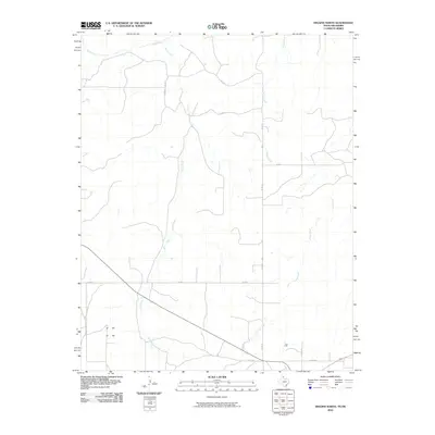
2010 Map of Higgins North
USGS Topo · Published 2010About this map
Wolf Creek and its southern tributaries define the drainage patterns of this Texas Panhandle landscape, where the High Plains transition into a network of seasonal watercourses. The territory is organized by a geometric grid of rural routes, including Co Rd 29 and Co Rd Y, which facilitate movement through a region dominated by agricultural use and open range. Several major draws, notably Camp Creek, Bridge Creek, and Long Creek, cut through the terrain from north to south, illustrating the natural erosion patterns typical of the region. This 2010 survey records the precise alignment of local infrastructure like Co Rd AA and Co Rd T against the natural topography, providing a detailed record of land use and water management in Lipscomb County.
Find a feature on this map
11 named features on this map. Tap any name to fly to it.
Don’t see what you’re looking for? This feature index may not catch every label — zoom into the map to look around manually.
Map Details
Editions of this 2010 Higgins North Map
This is the sole edition of this map. No revisions or reprints were ever made.
Other maps of this area

1954 · Perryton
USGS Topo · 1:250,000

1955 · Woodward
USGS Topo · 1:250,000

1958 · Perryton
USGS Topo · 1:250,000

1958 · Woodward
USGS Topo · 1:250,000

1969 · Shattuck
USGS Topo · 1:24,000
1970 · Arnett SW
USGS Topo · 1:24,000

1970 · Goodwin
USGS Topo · 1:24,000

1972 · Follett SE
USGS Topo · 1:24,000

1972 · Skunk Creek
USGS Topo · 1:24,000
1972 · Higgins North
USGS Topo · 1:24,000