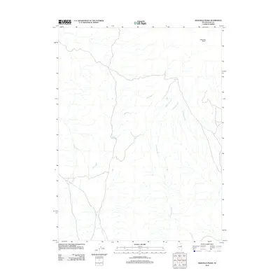
2012 Map of High Bald Peaks
USGS Topo · Published 2012About this map
The high desert landscape of eastern Nevada is defined by the High Bald Peaks, which rise above a network of seasonal drainage patterns in Elko County. This 2012 survey by the U.S. Geological Survey captures a complex hydrographic system where Ruby Wash and Long Valley Wash dominate the local topography. These intermittent watercourses, including the smaller Little Crooked Run and Klingermans Run, suggest a terrain shaped by rare but significant flash flood events. The presence of Mat Tank indicates a critical point for water storage in an otherwise arid environment, typical of the Great Basin's high-elevation rangelands. The map reveals the intricate natural contours and the essential water features that dictate land use and movement through this section of the Nevada wilderness.
Find a feature on this map
6 named features on this map. Tap any name to fly to it.
Don’t see what you’re looking for? This feature index may not catch every label — zoom into the map to look around manually.
Map Details
Editions of this 2012 High Bald Peaks Map
This is the sole edition of this map. No revisions or reprints were ever made.
Other maps of this area

1955 · Elko
USGS Topo · 1:250,000

1958 · Elko
USGS Topo · 1:250,000

1962 · Elko
USGS Topo · 1:250,000

1965 · Elko
USGS Topo · 1:250,000
1968 · Franklin Lake SE
USGS Topo · 1:24,000
1968 · Ruby Lake SE
USGS Topo · 1:24,000
1968 · Ruby Lake NE
USGS Topo · 1:24,000
1984 · High Bald Peaks SE
USGS Topo · 1:24,000
1984 · High Bald Peaks
USGS Topo · 1:24,000
1984 · Medicine Spring
USGS Topo · 1:24,000