
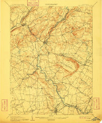
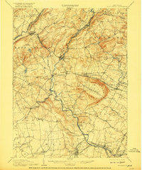
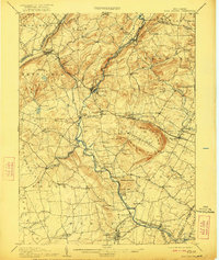
1905 Map of High Bridge
USGS Topo · Published 1905About this map
Cushetunk Mountain and the distinctive geological formation of Round Valley dominate the central landscape of Hunterdon County in this early twentieth-century survey. The area serves as a significant crossroads for rail transport, with the Central Railroad of New Jersey and the Lehigh Valley Railroad intersecting near High Bridge. This industrial and transit hub supported a network of smaller agricultural and mill settlements such as Readingsburg, Annandale, and Glen Gardner.
Find a feature on this map
98 named features on this map. Tap any name to fly to it.
Don’t see what you’re looking for? This feature index may not catch every label — zoom into the map to look around manually.
Map Details
Editions of this 1905 High Bridge Map
4 editions found
Other maps of this area

1888 · Hackettstown
USGS Topo · 1:62,500

1888 · Princeton
USGS Topo · 1:62,500

1888 · Lake Hopatcong
USGS Topo · 1:62,500

1890 · Easton
USGS Topo · 1:62,500

1890 · High Bridge
USGS Topo · 1:62,500

1890 · Lambertville
USGS Topo · 1:62,500

1890 · Doylestown
USGS Topo · 1:62,500

1891 · Somerville
USGS Topo · 1:62,500

1891 · Easton
USGS Topo · 1:62,500

1891 · Lambertville
USGS Topo · 1:62,500