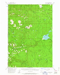
1956 Map of High Rock
USGS Topo · Published 1963About this map
Mt Hood National Forest dominates this mid-century survey, showcasing a landscape defined by forestry management and the emergence of recreational infrastructure in the Cascades. The expansive Timothy Lake serves as a central landmark, surrounded by several newly established campsites such as Hood View Campground and Gone Creek Campground. The map details the intricate network of fire prevention and backcountry access, featuring the High Rock Lookout and Wolf Camp Butte Lookout, alongside the historic Oregon Skyline Trail. These features reflect an era when the forest was transitioning from a purely industrial timber resource to a major destination for camping and hiking. Natural landmarks like Salmon Butte and Little Crater Lake are documented alongside specialized sites like Shellrock Forest Camp and the remote Pot Cr Cabin, illustrating the deep reach of federal forest administration into the Clackamas County backcountry.
Find a feature on this map
81 named features on this map. Tap any name to fly to it.
Don’t see what you’re looking for? This feature index may not catch every label — zoom into the map to look around manually.
Map Details
Editions of this 1956 High Rock Map
3 editions found

Other maps of this area

1916 · Estacada
USGS Topo · 1:125,000

1924 · Mount Hood
USGS Topo · 1:125,000

1927 · Mount Hood
USGS Topo · 1:125,000

1927 · Mt. Jefferson
USGS Topo · 1:125,000

1929 · Mill City
USGS Topo · 1:125,000

1930 · Mt. Jefferson
USGS Topo · 1:125,000

1948 · Vancouver
USGS Topo · 1:250,000

1950 · Vancouver
USGS Topo · 1:250,000

1950 · Vancouver
USGS Topo · 1:250,000

1953 · Salem
USGS Topo · 1:250,000