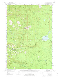
1956 Map of High Rock
USGS Topo · Published 1974About this map
Timothy Lake serves as a central anchor for this mid-century survey of the Oregon Cascades, showing the reservoir and its surrounding recreational infrastructure shortly after its creation. The landscape is defined by its network of forest camps and early recreation sites, including Meditation Point Campground, Hood View Campground, and High Rock Spr Campground. High points like Salmon Butte, Wolf Peak, and Oak Grove Butte overlook a complex drainage system fed by the Roaring River and Clackamas River.
Find a feature on this map
94 named features on this map. Tap any name to fly to it.
Don’t see what you’re looking for? This feature index may not catch every label — zoom into the map to look around manually.
Map Details
Editions of this 1956 High Rock Map
3 editions found

Other maps of this area

1916 · Estacada
USGS Topo · 1:125,000

1924 · Mount Hood
USGS Topo · 1:125,000

1927 · Mount Hood
USGS Topo · 1:125,000

1927 · Mt. Jefferson
USGS Topo · 1:125,000

1929 · Mill City
USGS Topo · 1:125,000

1930 · Mt. Jefferson
USGS Topo · 1:125,000

1948 · Vancouver
USGS Topo · 1:250,000

1950 · Vancouver
USGS Topo · 1:250,000

1950 · Vancouver
USGS Topo · 1:250,000

1953 · Salem
USGS Topo · 1:250,000