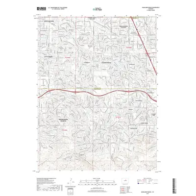
2019 Map of Highlands Ranch
USGS Topo · Published 2019About this map
Highlands Ranch and the southern Denver metropolitan area are defined by a complex network of planned residential developments and educational institutions. This 2019 survey captures the modern landscape of Douglas County and Arapahoe County, where the historical Highline Canal and Arapahoe Canal wind through established neighborhoods like Southglenn and Centennial. The region is a notable hub for higher education, featuring campuses for Metropolitan State University of Denver, Golden Gate Baptist Theological Seminary, and Devry University. The natural topography of Highlands Point and the drainage basins of Big Dry Creek and Marcy Gulch contrast with the dense infrastructure of Englewood and Littleton. Significant burial and memorial sites, such as Olinger Chapel Hill Memorial Gardens, are preserved amidst the suburban expansion.
Find a feature on this map
93 named features on this map. Tap any name to fly to it.
Don’t see what you’re looking for? This feature index may not catch every label — zoom into the map to look around manually.
Map Details
Editions of this 2019 Highlands Ranch Map
This is the sole edition of this map. No revisions or reprints were ever made.
Other maps of this area

1890 · East Denver
USGS Topo · 1:125,000

1893 · Platte Canyon
USGS Topo · 1:125,000

1894 · Castle Rock
USGS Topo · 1:125,000

1899 · West Denver
USGS Topo · 1:125,000

1913 · Castle Rock
USGS Topo · 1:125,000

1935 · East Denver Nos. 3 and 4
USGS Topo · 1:48,000

1940 · Englewood
USGS Topo · 1:31,680

1940 · Castle Rock
USGS Topo · 1:62,500

1941 · Fitzsimons
USGS Topo · 1:31,680

1941 · Fort Logan
USGS Topo · 1:31,680