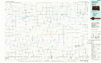
1985 Map of Highmore
USGS Topo · Published 1986About this map
The Chicago and North Western railroad corridor serves as the primary East-West axis for settlement across this central South Dakota landscape during the mid-1980s. Key towns such as Highmore, Miller, and Ree Heights are positioned along the tracks, surrounded by an intricate network of ephemeral water bodies and dedicated conservation areas. The map reveals a land structured by both utility and preservation, with numerous State Game Production Areas and National Waterfowl Production Areas interspersed among the section lines. Significant landmarks like Cottonwood Lake and Stone Lake punctuate the plains, while the Bald Hills provide localized relief. Small landing strips, including the Fischer Landing Strip and Nelson Landing Strip, reflect the regional reliance on private aviation. The northern reaches of the quadrangle are less densely settled, featuring isolated outposts like Polo and Orient connected by a grid of rural roads.
Find a feature on this map
55 named features on this map. Tap any name to fly to it.
Don’t see what you’re looking for? This feature index may not catch every label — zoom into the map to look around manually.
Map Details
Editions of this 1985 Highmore Map
3 editions found
Other maps of this area

1899 · Northville
USGS Topo · 1:125,000

1899 · Redfield
USGS Topo · 1:125,000

1934 · Canning
USGS Topo · 1:48,000

1937 · Canning
USGS Topo · 1:62,500

1949 · Ree Heights NW
USGS Topo · 1:24,000

1949 · Mitchell Lake
USGS Topo · 1:24,000

1950 · Ree Heights SE
USGS Topo · 1:24,000

1950 · Highmore NE
USGS Topo · 1:24,000

1950 · Mitchell Lake
USGS Topo · 1:24,000

1950 · Highmore
USGS Topo · 1:24,000