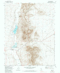
1970 Map of Hiko
USGS Topo · Published 1985About this map
Pahranagat Valley is defined here by its essential water sources, centered on the settlement of Hiko and the vital Hiko Spring. The landscape transitions from the irrigated valley floor, managed in part by the Key Pittman Wildlife Management Area, to the steep contours of the Hiko Range and the wide expanse of Six Mile Flat to the east.
Find a feature on this map
23 named features on this map. Tap any name to fly to it.
Don’t see what you’re looking for? This feature index may not catch every label — zoom into the map to look around manually.
Map Details
Editions of this 1970 Hiko Map
2 editions found
Other maps of this area

1945 · Alamo
USGS Topo · 1:125,000

1954 · Caliente
USGS Topo · 1:250,000

1959 · Caliente
USGS Topo · 1:250,000

1969 · Alamo NE
USGS Topo · 1:24,000

1969 · Ash Springs
USGS Topo · 1:24,000

1970 · Hiko NE
USGS Topo · 1:24,000

1970 · Hiko SE
USGS Topo · 1:24,000

1970 · Fossil Peak
USGS Topo · 1:24,000

1970 · Hiko
USGS Topo · 1:24,000
1983 · Hancock Summit
USGS Topo · 1:24,000