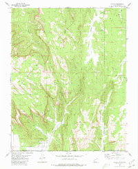
1980 Map of Hildale
USGS Topo · Published 1980About this map
Hildale sits at the southern edge of this survey, where the settlement meets the striking geologic breaks of the Vermilion Cliffs. The landscape is dominated by high-elevation plateaus and deeply carved drainages, including Water Canyon and Cottonwood Canyon, which carry seasonal flow from the northern heights toward the Arizona border. Geologic landmarks like The Beehive and South Mountain anchor the central terrain, while a network of high-desert water sources such as Cappies Rock Spring, Ronsio Spring, and Goat Springs provided critical resources for the region's early development.
Find a feature on this map
23 named features on this map. Tap any name to fly to it.
Don’t see what you’re looking for? This feature index may not catch every label — zoom into the map to look around manually.
Map Details
Editions of this 1980 Hildale Map
2 editions found
Other maps of this area

1885 · St. George
USGS Topo · 1:250,000

1886 · Kanab
USGS Topo · 1:250,000

1886 · Mt. Trumbull
USGS Topo · 1:250,000

1886 · Kaibab
USGS Topo · 1:250,000

1891 · St. George
USGS Topo · 1:250,000

1892 · Mt. Trumbull
USGS Topo · 1:250,000

1953 · Cedar City
USGS Topo · 1:250,000

1953 · Grand Canyon
USGS Topo · 1:250,000

1954 · La Verkin 4 SE
USGS Topo · 1:24,000
1954 · Short Creek NW
USGS Topo · 1:24,000