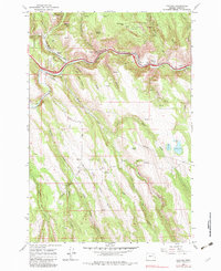
1963 Map of Hilgard
USGS Topo · Published 1983About this map
The Grande Ronde River carves a central path through this portion of the Whitman National Forest, serving as a vital corridor for both natural drainage and human transport. In the early 1960s, the Union Pacific railroad and a modern 4 Lane highway followed the river's winding course, connecting the small settlements of Hilgard and Perry. These mountain communities were built on the logistics of the era, evidenced by a Weighing Station, a Gaging Station, and a Gravel Pit positioned along the primary transit lines.
Find a feature on this map
46 named features on this map. Tap any name to fly to it.
Don’t see what you’re looking for? This feature index may not catch every label — zoom into the map to look around manually.
Map Details
Editions of this 1963 Hilgard Map
3 editions found
Other maps of this area

1953 · Pendleton
USGS Topo · 1:250,000

1956 · Pendleton
USGS Topo · 1:250,000

1963 · La Grande SE
USGS Topo · 1:24,000

1963 · Hilgard
USGS Topo · 1:24,000

1963 · Summerville
USGS Topo · 1:24,000

1964 · Huron
USGS Topo · 1:24,000

1964 · Drumhill Ridge
USGS Topo · 1:24,000

1964 · Kamela SE
USGS Topo · 1:24,000
1965 · Glass Hill
USGS Topo · 1:24,000

1965 · Little Beaver Creek
USGS Topo · 1:24,000