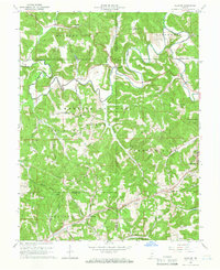
1965 Map of Hillham
USGS Topo · Published 1966About this map
The Lost River meanders through the heart of the Hoosier National Forest in this mid-century look at the borderlands of Orange, Martin, and Dubois counties. The terrain is defined by complex ridges like Pheasant Farm Ridge and Emmons Ridge, where small family cemeteries and remote churches, such as Hawkins Cem and New Antioch Ch & Cem, dot the high ground above the narrow valley floors. To the southeast, the famous resort town of French Lick is visible, adjacent to a Golf Course and the French Lick Municipal Airport. This area's transition from limestone extraction at the Red Quarry to a recreational and conservation landscape is evident. Further south, the Southern railroad line cuts through the topography, utilizing the Burton Tunnel near the settlement of Hillham, illustrating the engineering required to navigate this portion of southern Indiana.
Find a feature on this map
69 named features on this map. Tap any name to fly to it.
Don’t see what you’re looking for? This feature index may not catch every label — zoom into the map to look around manually.
Map Details
Editions of this 1965 Hillham Map
2 editions found
Other maps of this area

1948 · Huron
USGS Topo · 1:24,000

1949 · Georgia
USGS Topo · 1:24,000

1950 · Huron
USGS Topo · 1:24,000

1950 · Shoals
USGS Topo · 1:24,000

1951 · Hillham
USGS Topo · 1:24,000

1951 · French Lick
USGS Topo · 1:24,000

1951 · Georgia
USGS Topo · 1:24,000

1954 · Dubois
USGS Topo · 1:24,000

1956 · Greenbrier
USGS Topo · 1:24,000

1956 · Rusk
USGS Topo · 1:24,000