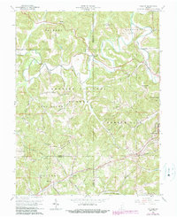
1965 Map of Hillham
USGS Topo · Published 1989About this map
The meandering Lost River carves a complex path through this portion of the Hoosier National Forest on the border of Martin, Orange, and Dubois Counties. The landscape is defined by its karst topography and prominent ridges, most notably Emmons Ridge, which is flanked by the steep ravines of Rattlesnake Hollow and Happy Hollow. This mid-century survey captures the region as it transitioned toward modern infrastructure, featuring the French Lick Municipal Airport and a network of named rural routes like Powell Valley Road and Emmons Ridge Road. Geologic and local history markers are abundant, from the mysterious Outlaw Cave to the Burton Tunnel and scattered limestone quarries. Small communities and family landmarks, such as Natchez, Hillham, and the Hawkins Cem, provide essential data for those tracing the ancestral settlements of the French Lick area.
Find a feature on this map
64 named features on this map. Tap any name to fly to it.
Don’t see what you’re looking for? This feature index may not catch every label — zoom into the map to look around manually.
Map Details
Editions of this 1965 Hillham Map
2 editions found
Other maps of this area

1948 · Huron
USGS Topo · 1:24,000

1949 · Georgia
USGS Topo · 1:24,000

1950 · Huron
USGS Topo · 1:24,000

1950 · Shoals
USGS Topo · 1:24,000

1951 · Hillham
USGS Topo · 1:24,000

1951 · French Lick
USGS Topo · 1:24,000

1951 · Georgia
USGS Topo · 1:24,000

1954 · Dubois
USGS Topo · 1:24,000

1956 · Greenbrier
USGS Topo · 1:24,000

1956 · Rusk
USGS Topo · 1:24,000