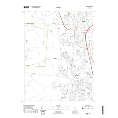
2019 Map of Hilliard
USGS Topo · Published 2019About this map
Hilliard and the northwestern edge of Columbus occupy the eastern half of this landscape, where suburban expansion meets the agricultural legacy of Union and Franklin Counties. The topography is defined by an intricate network of drainage systems, including Clover Groff Ditch and Hamilton Ditch, which channel water toward the western border near Big Darby Creek. This modern survey documents the persistent identity of smaller locales like Amlin, Hayden, and Mudsock as they are increasingly integrated into the growing metropolitan corridor.
Find a feature on this map
258 named features on this map. Tap any name to fly to it.
Don’t see what you’re looking for? This feature index may not catch every label — zoom into the map to look around manually.
Map Details
Editions of this 2019 Hilliard Map
This is the sole edition of this map. No revisions or reprints were ever made.
Other maps of this area

1901 · Dublin
USGS Topo · 1:62,500

1903 · Dublin
USGS Topo · 1:62,500

1907 · London
USGS Topo · 1:62,500

1916 · Milford Center
USGS Topo · 1:62,500

1923 · West Columbus
USGS Topo · 1:62,500

1925 · West Columbus
USGS Topo · 1:62,500

1944 · Milford Center
USGS Topo · 1:62,500

1947 · Columbus
USGS Topo · 1:250,000

1950 · Marion
USGS Topo · 1:250,000
1954 · Shawnee Hills
USGS Topo · 1:24,000