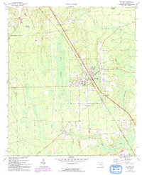
1970 Map of Hilliard
USGS Topo · Published 1992About this map
The town of Hilliard serves as the central hub of this North Florida landscape, where the Seaboard Coast Line railroad cuts a straight diagonal through the low-lying terrain of western Nassau County. This survey captures a mix of timberland and marshy basins, specifically the expansive Buford Bay and the winding course of the Little St Marys River. Local history is anchored by rural institutions like Buford Grove Ch and Bethel Ch, alongside established burial grounds such as Oakwood Cem and St Theresa Cem. The map documents a period of early aviation and infrastructure, noting a Landing Strip and Lookout Tower near the town center, while smaller communities like Andrews and a Trailer Park indicate the residential footprint of the early 1970s. Industrial activity is visible through scattered Sandpit sites and a Weigh Sta situated north of the main settlement.
Find a feature on this map
37 named features on this map. Tap any name to fly to it.
Don’t see what you’re looking for? This feature index may not catch every label — zoom into the map to look around manually.
Map Details
Editions of this 1970 Hilliard Map
2 editions found
Other maps of this area

1917 · Boulogne
USGS Topo · 1:62,500

1917 · Hilliard
USGS Topo · 1:62,500

1918 · Folkston
USGS Topo · 1:62,500

1918 · Moniac
USGS Topo · 1:62,500

1919 · Hilliard
USGS Topo · 1:62,500

1919 · Boulogne
USGS Topo · 1:62,500

1942 · Moniac
USGS Topo · 1:62,500

1948 · Jacksonville
USGS Topo · 1:250,000

1954 · Valdosta
USGS Topo · 1:250,000

1957 · Jacksonville
USGS Topo · 1:250,000