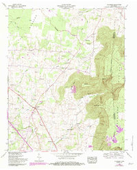
1953 Map of Hillsboro
USGS Topo · Published 1983About this map
The Cumberland Plateau rises sharply on the eastern edge of this Tennessee landscape, creating a dramatic topographical transition from the lower flatlands known as The Barrens. The Dixie Highway West serves as the primary artery through the region, passing through the central settlement of Hillsboro. This era of development shows a community deeply rooted in its geography, with numerous family-named cemeteries such as Winton Cem, Gentry Cem, and Crockett Cem scattered across the valley.
Find a feature on this map
59 named features on this map. Tap any name to fly to it.
Don’t see what you’re looking for? This feature index may not catch every label — zoom into the map to look around manually.
Map Details
Editions of this 1953 Hillsboro Map
3 editions found
Other maps of this area

1893 · Mc Minnville
USGS Topo · 1:125,000

1895 · Mc Minnville
USGS Topo · 1:125,000

1895 · Sewanee
USGS Topo · 1:125,000

1913 · Hollow Springs
USGS Topo · 1:62,500

1936 · Alto
USGS Topo · 1:24,000

1936 · Fredonia
USGS Topo · 1:24,000

1936 · Manchester
USGS Topo · 1:24,000

1936 · Burrow Cove
USGS Topo · 1:24,000

1936 · Morrison
USGS Topo · 1:24,000

1936 · Hillsboro
USGS Topo · 1:24,000