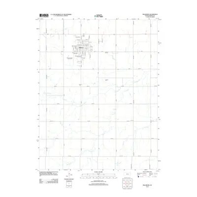
2012 Map of Hillsboro
USGS Topo · Published 2012About this map
Hillsboro serves as the focal point of this Marion County survey, anchored by the campus of Tabor Coll and the extensive Marion County Fairgrounds. The city's grid is detailed down to individual streets like W Grand Ave and S Main St, showing a community integrated with recreational and aviation assets such as the Hillsboro Municipal Golf Course and the Alfred Schroeder Field Airport. Beyond the city limits, the landscape transitions into a network of section-line roads like 190th and Old US Hwy 56 that crisscross the drainage basins of the S Cottonwood River and Antelope Cr. The map is particularly valuable for genealogical research, documenting several rural burial sites including Gnadenau Cem and Gard Cem, which reflect the early settlement patterns and immigrant heritage of this Kansas prairie region.
Find a feature on this map
62 named features on this map. Tap any name to fly to it.
Don’t see what you’re looking for? This feature index may not catch every label — zoom into the map to look around manually.
Map Details
Editions of this 2012 Hillsboro Map
This is the sole edition of this map. No revisions or reprints were ever made.
Other maps of this area

1889 · Newton
USGS Topo · 1:125,000

1894 · Newton
USGS Topo · 1:125,000

1955 · Hutchinson
USGS Topo · 1:250,000

1957 · Peabody NW
USGS Topo · 1:24,000

1957 · Peabody
USGS Topo · 1:24,000

1959 · Hutchinson
USGS Topo · 1:250,000

1965 · Goessel
USGS Topo · 1:24,000

1971 · Durham
USGS Topo · 1:24,000
1971 · Lehigh
USGS Topo · 1:24,000
1971 · Waldeck
USGS Topo · 1:24,000