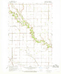
1967 Map of Hillsboro NW
USGS Topo · Published 1969About this map
The Goose River meanders sharply across this eastern North Dakota prairie, defining a landscape of agricultural drainage and early settlement in Traill County. Surveyed in the mid-1960s, the terrain is characterized by an extensive network of managed waterways including the Hanson Drain, Miller Drain No 29, and Mayville Drain, illustrating the region's intensive water management for farming. The Great Northern railroad cuts through the southwestern corner, serving the township of Blanchard. This map provides significant detail for genealogists, recording the locations of rural community centers like Norway Ch and Aal Ch, alongside the Arnegard Cem and Carlson Cem. The transition from the North Branch Goose River to the main stem showcases the complex oxbows and riparian vegetation that stand in contrast to the surrounding section-line grid.
Find a feature on this map
24 named features on this map. Tap any name to fly to it.
Don’t see what you’re looking for? This feature index may not catch every label — zoom into the map to look around manually.
Map Details
Editions of this 1967 Hillsboro NW Map
This is the sole edition of this map. No revisions or reprints were ever made.
Other maps of this area

1918 · Kelso
USGS Topo · 1:62,500

1943 · Kelso
USGS Topo · 1:62,500

1952 · Grand Forks
USGS Topo · 1:250,000

1956 · Grand Forks
USGS Topo · 1:250,000

1963 · Hillsboro
USGS Topo · 1:24,000

1963 · Kelso
USGS Topo · 1:24,000

1966 · Grand Forks
USGS Topo · 1:250,000

1967 · Mayville South
USGS Topo · 1:24,000

1967 · Blanchard
USGS Topo · 1:24,000
1968 · Galesburg SE
USGS Topo · 1:24,000