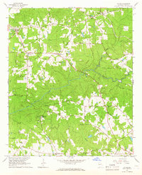
1964 Map of Hilyer
USGS Topo · Published 1966About this map
The Atlantic Coast Line railroad cuts through the northeastern corner of this Troup County landscape, connecting the rural communities of Hilyer and Big Springs. This 1964 survey captures a moment when small agricultural hubs and family homesteads still defined the region, as evidenced by the high density of family-named cemeteries such as Talley Cem, McGee Cem, and Sledge Cem. The area is heavily drained by a network of waterways including Mud Creek, Flat Shoal Creek, and Sulphur Creek, which likely supported early local industries such as Smiths Mill. Educational and social life centered around landmarks like the Rosemont Sch and various congregations, including Threats Grove Ch and Pleasant Grove Ch. The presence of the Boy Scout Camp near Rosemont Road further illustrates the era's focus on local community development.
Find a feature on this map
66 named features on this map. Tap any name to fly to it.
Don’t see what you’re looking for? This feature index may not catch every label — zoom into the map to look around manually.
Map Details
Editions of this 1964 Hilyer Map
2 editions found
Other maps of this area

1899 · Wedowee
USGS Topo · 1:125,000

1902 · Wedowee
USGS Topo · 1:125,000

1907 · Talbotton
USGS Topo · 1:125,000

1907 · Opelika
USGS Topo · 1:125,000

1909 · Opelika
USGS Topo · 1:125,000

1953 · Atlanta
USGS Topo · 1:250,000

1955 · Phenix City
USGS Topo · 1:250,000

1957 · Phenix City
USGS Topo · 1:250,000

1957 · Atlanta
USGS Topo · 1:250,000

1958 · Phenix City
USGS Topo · 1:250,000