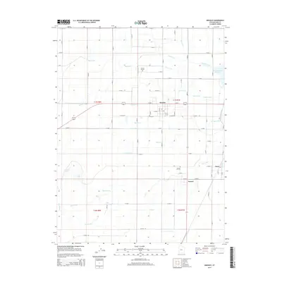
2014 Map of Hinckley
USGS Topo · Published 2014About this map
Hinckley and the surrounding agricultural basin of Millard County are defined by an intricate network of irrigation infrastructure designed to harness the Sevier River. This 2014 survey details the complex system of canals and ditches, such as the Abraham Canal, Wilson Canal, and Highline Canal, which transformed this arid landscape into a productive farming region. The settlements of Deseret and Oasis sit downstream, where the river's flow is managed by the Gunnison Bend Reservoir. To the west, the terrain shifts away from the orderly grid of section lines and ditches into more varied topography featuring Cockleburr Lake, Deep Lake, and the Pete Black Cut. For local historians and genealogists, the map provides precise locations for the Hinckley City Cem and Deseret City Cem, alongside numerous named waterworks like the Nielson Ditch and Blake Ditch that speak to the area's long-standing water management history.
Find a feature on this map
83 named features on this map. Tap any name to fly to it.
Don’t see what you’re looking for? This feature index may not catch every label — zoom into the map to look around manually.
Map Details
Editions of this 2014 Hinckley Map
This is the sole edition of this map. No revisions or reprints were ever made.
Other maps of this area

1885 · Sevier Desert
USGS Topo · 1:250,000

1953 · Delta
USGS Topo · 1:250,000

1958 · Delta
USGS Topo · 1:250,000

1962 · Delta
USGS Topo · 1:250,000

1962 · Delta
USGS Topo · 1:62,500

1971 · Smelter Knolls East
USGS Topo · 1:24,000

1971 · Pavant Butte North
USGS Topo · 1:24,000

1971 · Sunstone Knoll
USGS Topo · 1:24,000
1971 · Pot Mountain
USGS Topo · 1:24,000
1971 · Crafts Lake
USGS Topo · 1:24,000