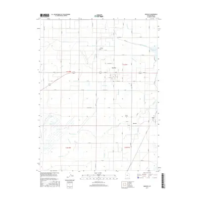
2017 Map of Hinckley
USGS Topo · Published 2017About this map
Hinckley and the surrounding Millard County landscape are defined by an intricate network of irrigation infrastructure and the meandering path of the Sevier River. This 2017 survey details the intensive water management systems essential to the region, including the Abraham Canal, Highline Canal, and numerous community-managed watercourses like the Town Ditch and Neeley Ditch. The settlement patterns of Deseret and Oasis are clearly visible, oriented around these vital waterways. Evidence of earlier hydrological shifts remains in the Old Channel and the Pete Black Cut, illustrating how the community has historically adapted to the river's movement. Further west, the terrain shifts towards natural water bodies like Cockleburr Lake and Deep Lake. Local history is anchored by the Hinckley City Cem and Deseret City Cem, providing essential points of reference for genealogists tracing families in these agricultural hubs.
Find a feature on this map
85 named features on this map. Tap any name to fly to it.
Don’t see what you’re looking for? This feature index may not catch every label — zoom into the map to look around manually.
Map Details
Editions of this 2017 Hinckley Map
This is the sole edition of this map. No revisions or reprints were ever made.
Other maps of this area

1885 · Sevier Desert
USGS Topo · 1:250,000

1953 · Delta
USGS Topo · 1:250,000

1958 · Delta
USGS Topo · 1:250,000

1962 · Delta
USGS Topo · 1:250,000

1962 · Delta
USGS Topo · 1:62,500

1971 · Smelter Knolls East
USGS Topo · 1:24,000

1971 · Pavant Butte North
USGS Topo · 1:24,000

1971 · Sunstone Knoll
USGS Topo · 1:24,000
1971 · Pot Mountain
USGS Topo · 1:24,000
1971 · Crafts Lake
USGS Topo · 1:24,000