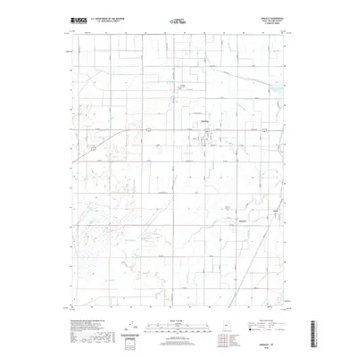
2020 Map of Hinckley
USGS Topo · Published 2020About this map
Irrigation infrastructure and the winding course of the Sevier River dominate this Millard County landscape, centered on the historic settlements of Hinckley and Deseret. A sophisticated network of man-made waterways, including the Abraham Canal, Highline Canal, and Will Ruben Canal, illustrates the intensive water management required to support this agricultural valley. Near the town of Oasis, the landscape transitions toward wetlands and seasonal basins such as Cocklebur Lake and Deep Lake. Local genealogy is anchored by the Hinckley City Cem and Deseret City Cem, while the Gunnison Bend Reservoir serves as a major landmark in the northeast. The presence of numerous named ditches like Nielson-Ditch and Blake-Ditch reveals a highly subdivided system of water rights and land use, tracing a pattern of settlement and reclamation that has defined this portion of the Great Basin for generations.
Find a feature on this map
72 named features on this map. Tap any name to fly to it.
Don’t see what you’re looking for? This feature index may not catch every label — zoom into the map to look around manually.
Map Details
Editions of this 2020 Hinckley Map
This is the sole edition of this map. No revisions or reprints were ever made.
Other maps of this area

1885 · Sevier Desert
USGS Topo · 1:250,000

1953 · Delta
USGS Topo · 1:250,000

1958 · Delta
USGS Topo · 1:250,000

1962 · Delta
USGS Topo · 1:250,000

1962 · Delta
USGS Topo · 1:62,500

1971 · Smelter Knolls East
USGS Topo · 1:24,000

1971 · Pavant Butte North
USGS Topo · 1:24,000

1971 · Sunstone Knoll
USGS Topo · 1:24,000
1971 · Pot Mountain
USGS Topo · 1:24,000
1971 · Crafts Lake
USGS Topo · 1:24,000