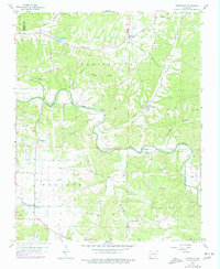
1958 Map of Hindsville
USGS Topo · Published 1977About this map
Hindsville and the surrounding rural uplands of the Ozarks are detailed in this late 1950s survey, showing the dispersed farmstead patterns and community focal points of Madison County. The landscape is defined by the winding course of War Eagle Creek and its many tributaries, including Clear Creek and Clifty Creek. Social life in this era centered around a network of country churches and small schools, such as Hickory Grove Ch, Lone Star Ch, and the Spring Clear Creek Sch.
Find a feature on this map
31 named features on this map. Tap any name to fly to it.
Don’t see what you’re looking for? This feature index may not catch every label — zoom into the map to look around manually.
Map Details
Editions of this 1958 Hindsville Map
3 editions found
Other maps of this area

1900 · Eureka Springs
USGS Topo · 1:125,000

1901 · Eureka Springs
USGS Topo · 1:125,000

1945 · Harrison
USGS Topo · 1:250,000

1949 · Harrison
USGS Topo · 1:250,000

1954 · Harrison
USGS Topo · 1:250,000

1957 · Mundell
USGS Topo · 1:24,000

1957 · War Eagle
USGS Topo · 1:24,000
1958 · Goshen
USGS Topo · 1:24,000
1958 · Spring Valley
USGS Topo · 1:24,000

1958 · Hindsville
USGS Topo · 1:24,000