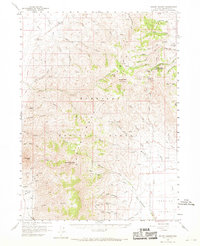
1959 Map of Hinkey Summit
USGS Topo · Published 1969About this map
Santa Rosa Peak and Granite Peak dominate this high-altitude landscape within the Humboldt National Forest, where the topography is defined by steep canyons and seasonal water sources. The map records a transition from high peaks down toward the north end of Paradise Valley, showing the complex drainage systems of Big Cottonwood Creek and Mullinix Creek. Human activity is centered around the forest's resources, indicated by the Martin Creek Ranger Station, the Solid Silver Mine, and scattered cattle ranching operations like the Flat Creek Ranch.
Find a feature on this map
53 named features on this map. Tap any name to fly to it.
Don’t see what you’re looking for? This feature index may not catch every label — zoom into the map to look around manually.
Map Details
Editions of this 1959 Hinkey Summit Map
3 editions found

Other maps of this area

1882 · Paradise
USGS Topo · 1:250,000

1893 · Paradise
USGS Topo · 1:250,000

1945 · Hot Springs
USGS Topo · 1:62,500

1947 · Hot Springs Peak
USGS Topo · 1:62,500

1955 · McDermitt
USGS Topo · 1:250,000

1958 · Paradise Valley
USGS Topo · 1:62,500

1958 · Awakening Peak
USGS Topo · 1:62,500

1959 · McDermitt
USGS Topo · 1:250,000

1959 · Orovada
USGS Topo · 1:62,500

1959 · McDermitt
USGS Topo · 1:62,500