1953 Map of Hinsdale
USGS Topo · Published 1956About this map
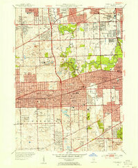
Hinsdale and its neighboring villages in DuPage and Cook counties exhibit the mid-century expansion of the Chicago suburbs, anchored by a dense network of commuter rail lines including the Chicago Burlington and Quincy RR and the Chicago Aurora and Elgin RR. The landscape is a mix of established residential grids and significant institutional footprints, such as the St Josephs Seminary and St Francis Retreat.
Find a feature on this map
101 named features on this map. Tap any name to fly to it.
Don’t see what you’re looking for? This feature index may not catch every label — zoom into the map to look around manually.
Map Details
Editions of this 1953 Hinsdale Map
This is the sole edition of this map. No revisions or reprints were ever made.
Other maps of this area

1890 · Des Plaines
USGS Topo · 1:62,500

1891 · Riverside
USGS Topo · 1:62,500

1892 · Joliet
USGS Topo · 1:62,500

1893 · Riverside
USGS Topo · 1:62,500

1894 · Des Plaines
USGS Topo · 1:62,500

1900 · Des Plaines
USGS Topo · 1:62,500

1900 · Riverside
USGS Topo · 1:62,500

1901 · Des Plaines
USGS Topo · 1:62,500

1901 · Riverside
USGS Topo · 1:62,500

1908 · Wheaton
USGS Topo · 1:62,500