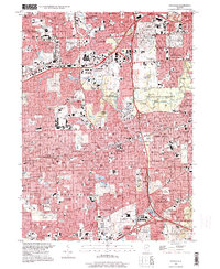
1997 Map of Hinsdale
USGS Topo · Published 1999About this map
The suburban corridor west of Chicago shows a dense network of residential communities and recreational spaces at the close of the 20th century. Major transportation arteries like the East-West Tollway and Tri-State Tollway intersect near Oakbrook, defining the rapid transit of the era. The landscape is notable for its extensive preserve system, including the Fullersburg Co Forest Preserve and York Woods Co Forest Preserve, which protect the meandering path of Salt Creek.
Find a feature on this map
122 named features on this map. Tap any name to fly to it.
Don’t see what you’re looking for? This feature index may not catch every label — zoom into the map to look around manually.
Map Details
Editions of this 1997 Hinsdale Map
This is the sole edition of this map. No revisions or reprints were ever made.
Other maps of this area

1890 · Des Plaines
USGS Topo · 1:62,500

1891 · Riverside
USGS Topo · 1:62,500

1892 · Joliet
USGS Topo · 1:62,500

1893 · Riverside
USGS Topo · 1:62,500

1894 · Des Plaines
USGS Topo · 1:62,500

1900 · Des Plaines
USGS Topo · 1:62,500

1900 · Riverside
USGS Topo · 1:62,500

1901 · Des Plaines
USGS Topo · 1:62,500

1901 · Riverside
USGS Topo · 1:62,500

1908 · Wheaton
USGS Topo · 1:62,500