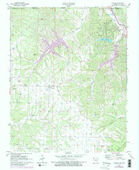
1971 Map of Hiwasse
USGS Topo · Published 1982About this map
Hiwasse and Bella Vista anchor this 1970s landscape along the Arkansas-Missouri border, a period when the northern Benton County hill country was transitioning toward a significant recreation-and-retirement destination. The northern reach of the map is defined by the winding course of Little Sugar Creek and the early development surrounding Loch Lomond and Lake Avalon. This growth contrasts with the more traditional rural layout to the south, where established farmsteads and rural social centers like Mt Olive Ch and Keith Ch remain central to the community fabric.
Find a feature on this map
28 named features on this map. Tap any name to fly to it.
Don’t see what you’re looking for? This feature index may not catch every label — zoom into the map to look around manually.
Map Details
Editions of this 1971 Hiwasse Map
3 editions found
Other maps of this area

1899 · Fayetteville
USGS Topo · 1:125,000

1901 · Fayetteville
USGS Topo · 1:125,000

1904 · Fayetteville
USGS Topo · 1:125,000

1940 · Noel
USGS Topo · 1:62,500

1941 · Rocky Comfort
USGS Topo · 1:62,500

1943 · Noel
USGS Topo · 1:62,500

1943 · Rocky Comfort
USGS Topo · 1:62,500

1954 · Tulsa
USGS Topo · 1:250,000

1958 · Tulsa
USGS Topo · 1:250,000

1963 · Tulsa
USGS Topo · 1:250,000