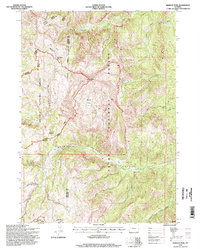
1996 Map of Hoback Peak
USGS Topo · Published 1998About this map
Hoback Peak dominates this high-altitude landscape on the boundary of the Bridger National Forest and Teton National Forest. This 1990s revision reveals a terrain defined by dramatic watercourses, including the Hoback River and the South Fork Hoback River, which carve through the Upper Hoback Canyon. The map details a remote wilderness infrastructure used by foresters and recreationists, including the High Line Trail and a designated Hunting Camp near the northeast corner. Notable topographical landmarks such as Bare Hole, Heaven, and Cliff Creek Pass provide specific waypoints for navigating the complex ridges and basins. Wide riparian grazing areas like Roosevelt Meadows and Horse Meadows indicate the traditional summer range patterns in this part of Sublette and Lincoln counties.
Find a feature on this map
25 named features on this map. Tap any name to fly to it.
Don’t see what you’re looking for? This feature index may not catch every label — zoom into the map to look around manually.
Map Details
Editions of this 1996 Hoback Peak Map
This is the sole edition of this map. No revisions or reprints were ever made.
Other maps of this area

1907 · Gros Ventre
USGS Topo · 1:125,000

1910 · Gros Ventre
USGS Topo · 1:125,000

1921 · Afton
USGS Topo · 1:125,000

1931 · Jackson
USGS Topo · 1:125,000

1935 · Jackson
USGS Topo · 1:125,000

1939 · Big Piney
USGS Topo · 1:125,000

1942 · Big Piney
USGS Topo · 1:125,000

1955 · Driggs
USGS Topo · 1:250,000

1955 · Preston
USGS Topo · 1:250,000

1958 · Driggs
USGS Topo · 1:250,000