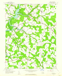
1944 Map of Hobbs
USGS Topo · Published 1962About this map
The Choptank River defines the western edge of this landscape, where historic river landings like Pealiquor Landing, Lyford Landing, and Potters Landing once served as vital commerce points for Caroline County. Inland, the terrain is marked by small settlements and rural crossroads such as Williston, Two Johns, and American Corner. The 1940s landscape is primarily agricultural, with small woodlots and farmsteads connected by a network of light-duty and unimproved roads. A remnant of earlier industrial transportation is visible in the north, where a Railroad Grade cuts through the woods near Hobbs. Social and spiritual life in the area is anchored by several country churches, including Todds Chapel, St Pauls Ch, and John Wesley Ch, providing specific points of interest for genealogists tracing family ties to these Eastern Shore communities.
Find a feature on this map
29 named features on this map. Tap any name to fly to it.
Don’t see what you’re looking for? This feature index may not catch every label — zoom into the map to look around manually.
Map Details
Editions of this 1944 Hobbs Map
3 editions found
Other maps of this area

1905 · Denton
USGS Topo · 1:62,500

1905 · Hurlock
USGS Topo · 1:62,500

1915 · Seaford
USGS Topo · 1:62,500

1918 · Harrington
USGS Topo · 1:62,500

1944 · Denton
USGS Topo · 1:31,680
1944 · Preston
USGS Topo · 1:31,680

1944 · Federalsburg
USGS Topo · 1:31,680
1944 · Ridgely
USGS Topo · 1:31,680

1944 · Seaford
USGS Topo · 1:62,500

1944 · Hobbs
USGS Topo · 1:31,680