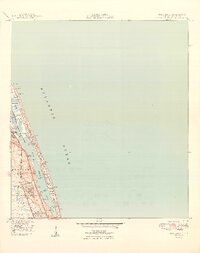
1949 Map of Hobe Sound
USGS Topo · Published 1949About this map
Jupiter Island and the coastal barrier system dominate this post-war landscape, showing the early infrastructure of Florida's Treasure Coast. The area is defined by the narrow channels of the Intracoastal Waterway and Jupiter Narrows, which separate the mainland from the exclusive developments on the coast. Near the Jupiter Island Club, the map records specific local landmarks including a US Coast Guard Station and several residential markers like Borden Hill (C) and Simpson Hill (C).
Find a feature on this map
30 named features on this map. Tap any name to fly to it.
Don’t see what you’re looking for? This feature index may not catch every label — zoom into the map to look around manually.
Map Details
Editions of this 1949 Hobe Sound Map
2 editions found
Other maps of this area

1948 · Rood
USGS Topo · 1:24,000

1948 · St. Lucie Inlet
USGS Topo · 1:24,000

1948 · Gomez
USGS Topo · 1:24,000

1948 · Hobe Sound
USGS Topo · 1:24,000

1948 · Jupiter
USGS Topo · 1:24,000

1949 · Rood
USGS Topo · 1:24,000

1949 · Gomez
USGS Topo · 1:24,000

1949 · Hobe Sound
USGS Topo · 1:24,000

1950 · St. Lucie Inlet
USGS Topo · 1:24,000

1950 · Jupiter
USGS Topo · 1:24,000