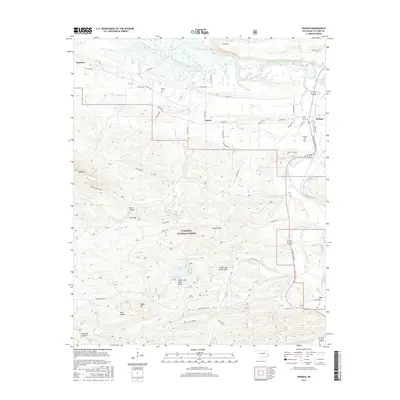
2016 Map of Hodgen
USGS Topo · Published 2016About this map
Ouachita National Forest dominates the southern half of this landscape, where steep ridges like Snake Mtn and Post Mtn rise above the valley floor. The map highlights a network of water bodies, including Cedar Lake with its distinct Cedar Lake North Shore and Cedar Lake South Shore recreation areas. Along the northern edge, the Poteau River meanders near the small communities of Reichert, Conser, and Hodgen. This area is marked by its transition from the managed timberlands of the forest to the low-lying river bottomlands where Conser Creek and Merle Br converge. Genealogy researchers can locate several rural burial grounds, including Naylor Cem, Perry Cem, and Hodgen Cem, which are tucked away along county roads like Conser Rd and Granny Bear Rd.
Find a feature on this map
60 named features on this map. Tap any name to fly to it.
Don’t see what you’re looking for? This feature index may not catch every label — zoom into the map to look around manually.
Map Details
Editions of this 2016 Hodgen Map
This is the sole edition of this map. No revisions or reprints were ever made.
Other maps of this area

1900 · Winding Stair
USGS Topo · 1:125,000

1909 · Winding Stair
USGS Topo · 1:125,000

1950 · Mcalester
USGS Topo · 1:250,000

1959 · Page
USGS Topo · 1:62,500

1959 · Heavener
USGS Topo · 1:62,500

1962 · McAlester
USGS Topo · 1:250,000

1965 · McAlester
USGS Topo · 1:250,000
1965 · Summerfield
USGS Topo · 1:24,000
1966 · Muse
USGS Topo · 1:24,000
1966 · Leflore SE
USGS Topo · 1:24,000