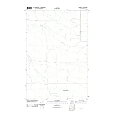
2011 Map of Hodges SE
USGS Topo · Published 2011About this map
Horse Creek and its tributaries define the drainage patterns of this Wibaux County landscape as it appeared in the early 21st century. The map reveals a highly structured grid of section lines and rural thoroughfares, such as Horse Creek Rd and Anvil Butte Rd, which facilitate movement through the open range. A significant local landmark is the J Witkowske Number 1 Dam, reflecting the critical importance of water management and storage in this part of Montana. Seasonal drainages like Wolf Creek and the South Fork Horse Creek carve subtle paths across the territory. The network of local routes, including Horse Point Rd and Pine Unit Rd, suggests a landscape dedicated to ranching and resource management typical of the High Plains.
Find a feature on this map
9 named features on this map. Tap any name to fly to it.
Don’t see what you’re looking for? This feature index may not catch every label — zoom into the map to look around manually.
Map Details
Editions of this 2011 Hodges SE Map
This is the sole edition of this map. No revisions or reprints were ever made.
Other maps of this area

1953 · Miles City
USGS Topo · 1:250,000

1957 · Miles City
USGS Topo · 1:250,000

1958 · Miles City
USGS Topo · 1:250,000

1981 · Cap Rock
USGS Topo · 1:24,000

1981 · Rocking Chair Butte
USGS Topo · 1:24,000
1981 · Carlyle NW
USGS Topo · 1:24,000

1981 · Wibaux
USGS Topo · 1:100,000
1982 · Hodges SE
USGS Topo · 1:24,000

1982 · Hodges
USGS Topo · 1:24,000
1982 · Red Top Butte
USGS Topo · 1:24,000