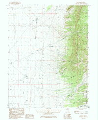
1987 Map of Hogum
USGS Topo · Published 1987About this map
The settlement of Osceola and the nearby site of Hogum anchor this 1980s landscape in the Snake Range. The map reveals an extensive history of resource extraction, marked by a dense concentration of prospects, mine shaft adits, and tailings piles. Notable industrial sites include the Crystal Queen Mine and a local gravel pit, indicating both precious metal exploration and infrastructure development.
Find a feature on this map
35 named features on this map. Tap any name to fly to it.
Don’t see what you’re looking for? This feature index may not catch every label — zoom into the map to look around manually.
Map Details
Editions of this 1987 Hogum Map
2 editions found
Other maps of this area

1948 · Wheeler Peak
USGS Topo · 1:62,500

1950 · Wheeler Peak
USGS Topo · 1:62,500

1952 · Ely
USGS Topo · 1:125,000

1956 · Lund
USGS Topo · 1:250,000

1956 · Ely
USGS Topo · 1:250,000

1959 · Ely
USGS Topo · 1:250,000

1959 · Sacramento Pass
USGS Topo · 1:62,500

1959 · Connors Pass
USGS Topo · 1:62,500

1960 · Lund
USGS Topo · 1:250,000

1963 · Ely
USGS Topo · 1:250,000