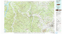
1986 Map of Hohenwald
USGS Topo · Published 1993About this map
The Duck River and Buffalo River carve deep, winding paths through the heart of middle Tennessee in the mid-1980s. This survey, compiled from data spanning the post-war decades, reveals a landscape defined by sharp elevation changes and high, narrow divides such as Missionary Ridge and Sassafras Stand Ridge. The regional economy is anchored by the Louisville and Nashville railroad corridor, connecting timber and agricultural communities like Hohenwald, Linden, and Centerville. Conservation areas are prominent across the western reaches, including the Tennessee National Wildlife Refuge Duck River Unit and Mouser Landing State Rustic Park.
Find a feature on this map
107 named features on this map. Tap any name to fly to it.
Don’t see what you’re looking for? This feature index may not catch every label — zoom into the map to look around manually.
Map Details
Editions of this 1986 Hohenwald Map
3 editions found
Other maps of this area

1901 · Colombia
USGS Topo · 1:125,000

1903 · Nashville
USGS Topo · 1:125,000

1905 · Waynesboro
USGS Topo · 1:125,000

1909 · Franklin
USGS Topo · 1:62,500

1930 · White Bluff
USGS Topo · 1:62,500

1932 · Nashville
USGS Topo · 1:62,500

1933 · White Bluff
USGS Topo · 1:62,500

1936 · Riverside
USGS Topo · 1:24,000

1936 · Gorman
USGS Topo · 1:24,000

1936 · Graves Spring
USGS Topo · 1:24,000