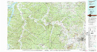
1986 Map of Hohenwald
USGS Topo · Published 1993About this map
Hohenwald and the rolling hill country of middle Tennessee are defined by an intricate network of waterways and historic overland routes in this mid-1980s landscape. The Natchez Trace Parkway winds through the heart of the region, passing the Meriwether Lewis National Monument and connecting ancient travel corridors with modern accessibility. The terrain is structured by prominent elevations like Duck River Ridge and Sassafras Stand Ridge, which separate the various watersheds of the Buffalo River, Piney River, and the wide Duck River.
Find a feature on this map
114 named features on this map. Tap any name to fly to it.
Don’t see what you’re looking for? This feature index may not catch every label — zoom into the map to look around manually.
Map Details
Editions of this 1986 Hohenwald Map
3 editions found
Other maps of this area

1901 · Colombia
USGS Topo · 1:125,000

1903 · Nashville
USGS Topo · 1:125,000

1905 · Waynesboro
USGS Topo · 1:125,000

1909 · Franklin
USGS Topo · 1:62,500

1930 · White Bluff
USGS Topo · 1:62,500

1932 · Nashville
USGS Topo · 1:62,500

1933 · White Bluff
USGS Topo · 1:62,500

1936 · Riverside
USGS Topo · 1:24,000

1936 · Gorman
USGS Topo · 1:24,000

1936 · Graves Spring
USGS Topo · 1:24,000