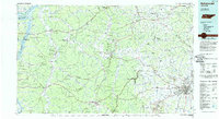
1986 Map of Hohenwald
USGS Topo · Published 1986About this map
Kentucky Lake and the Tennessee River dominate the western edge of this 1980s landscape, where the Tennessee National Wildlife Refuge Duck River Unit preserves the bottomlands at the confluence with the Duck River. The terrain is defined by a series of prominent ridges, most notably Sassafras Stand Ridge and Nine Mile Ridge, which dictate the winding paths of the Buffalo River and its numerous tributaries. These watercourses were historically vital to local industry, evidenced by settlements like Furnace and Farmers Exchange.
Find a feature on this map
127 named features on this map. Tap any name to fly to it.
Don’t see what you’re looking for? This feature index may not catch every label — zoom into the map to look around manually.
Map Details
Editions of this 1986 Hohenwald Map
3 editions found
Other maps of this area

1901 · Colombia
USGS Topo · 1:125,000

1903 · Nashville
USGS Topo · 1:125,000

1905 · Waynesboro
USGS Topo · 1:125,000

1909 · Franklin
USGS Topo · 1:62,500

1930 · White Bluff
USGS Topo · 1:62,500

1932 · Nashville
USGS Topo · 1:62,500

1933 · White Bluff
USGS Topo · 1:62,500

1936 · Riverside
USGS Topo · 1:24,000

1936 · Gorman
USGS Topo · 1:24,000

1936 · Graves Spring
USGS Topo · 1:24,000