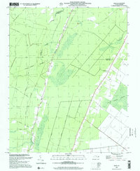
1997 Map of Hoke
USGS Topo · Published 2001About this map
Low-lying marshlands and industrial transport corridors define this coastal plain landscape where Beaufort, Washington, and Martin counties converge. The Norfolk Southern railroad runs north-south through the center of the sheet, passing through the small community of Hoke, which serves as a central point amidst the surrounding wetlands. This environment is dominated by expansive tracts like the East Dismal Swamp and Cabin Swamp, showing the persistent difficulty of drainage in the region despite a network of creeks including Welch Cr and Acre Swamp. Local transit and logging history is evidenced by named corridors such as Morris Tram Road, Diamond City Road, and Barber Road, while the cultural landscape is anchored by rural landmarks like Christian Hope Ch and Long Acre Chapel. Numerous unnamed Cem (cemeteries) are scattered along the higher ground of the ridges, offering valuable data points for genealogical research in this rural pocket of North Carolina.
Find a feature on this map
23 named features on this map. Tap any name to fly to it.
Don’t see what you’re looking for? This feature index may not catch every label — zoom into the map to look around manually.
Map Details
Editions of this 1997 Hoke Map
This is the sole edition of this map. No revisions or reprints were ever made.
Other maps of this area

1914 · Belhaven
USGS Topo · 1:48,000

1916 · Belhaven
USGS Topo · 1:62,500

1943 · Plymouth
USGS Topo · 1:125,000

1950 · Pinetown
USGS Topo · 1:24,000

1951 · Bunyan
USGS Topo · 1:24,000

1951 · Pantego
USGS Topo · 1:24,000

1953 · Rocky Mount
USGS Topo · 1:250,000

1954 · Rocky Mount
USGS Topo · 1:250,000

1954 · Plymouth East
USGS Topo · 1:24,000
1954 · Pike Road
USGS Topo · 1:24,000