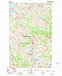
1988 Map of Holden
USGS Topo · Published 1988About this map
Holden sits as a primary point of interest in this high-altitude landscape within the Wenatchee National Forest. The map documents the area's industrial footprint, showing a Mine, several Prospects, and extensive Tailings along the banks of Holden Creek. This proximity of mineral extraction to the surrounding Glacier Peak Wilderness illustrates the complex land-use history of the Chelan Mountains during the late 20th century.
Find a feature on this map
43 named features on this map. Tap any name to fly to it.
Don’t see what you’re looking for? This feature index may not catch every label — zoom into the map to look around manually.
Map Details
Editions of this 1988 Holden Map
2 editions found
Other maps of this area

1902 · Stehekin
USGS Topo · 1:125,000

1904 · Stehekin
USGS Topo · 1:125,000

1944 · Holden
USGS Topo · 1:62,500

1944 · Lucerne
USGS Topo · 1:62,500

1949 · Lucerne
USGS Topo · 1:62,500

1949 · Holden
USGS Topo · 1:62,500

1955 · Concrete
USGS Topo · 1:250,000

1958 · Concrete
USGS Topo · 1:250,000

1962 · Concrete
USGS Topo · 1:250,000
1963 · Agnes Mtn
USGS Topo · 1:24,000